Gisborne's coastal position and the erodible hill country of the Tairāwhiti region create a unique challenge: soils here range from silty loess on the hills to loose alluvial sands and gravels in the Poverty Bay flats. The high annual rainfall, sitting around 1,100 mm, and the region's history of significant flood events mean that accurate grain size distribution data is not optional. A combined sieve and hydrometer analysis on a grab sample tells you exactly how much silt, sand, and gravel you're working with. When we run these tests in our lab, we're looking at the full particle-size curve because a missing fines fraction in a drainage layer can lead to premature clogging. For roading projects on SH35 or subdivision earthworks in Whataupoko, the grain size data feeds directly into NZGS soil group classification. We often pair this with Atterberg limits tests to confirm plasticity characteristics of the fines, which is essential for any cohesive soil encountered during Gisborne site investigations.
A 2% difference in fines content can shift a soil from a free-draining sand to a moisture-sensitive silty sand. The hydrometer catches what the sieves miss.
Technical details of the service in Gisborne
Local geotechnical conditions in Gisborne
NZS 3404 and NZGS guidelines require a complete particle-size distribution for defensible soil classification. In Gisborne, skipping the hydrometer on a material with visual fines is a direct risk. The Poverty Bay flats contain interbedded alluvial deposits where a thin silt layer can go unnoticed in a split-spoon sample. If that layer sits at footing depth, the undrained shear strength controls the design. Without the fines percentage from a hydrometer, you cannot reliably assign an NZGS group symbol, and you risk under-designing foundations or over-estimating permeability. For retaining wall drainage design, a soil with 8% fines versus 15% fines behaves completely differently under seepage. The 2007 Gisborne earthquake highlighted how silty sand layers with high fines content were prone to cyclic softening. A grain size curve is the first screening tool in any liquefaction assessment under the modified Youd-Idriss framework. Without it, the seismic design assumptions are guesswork.
Our services
Our Gisborne laboratory runs sieve and hydrometer analyses daily during the earthworks season. We provide the full particle-size distribution curve with NZGS classification and gradation coefficients.
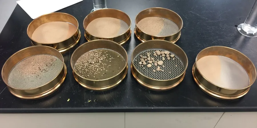
Combined Sieve and Hydrometer Analysis
Full particle-size distribution from 75 mm down to 2 microns. Includes oven-drying, sieve shaking, hydrometer sedimentation with temperature-corrected readings, and a plotted gradation curve. Delivered with Cu, Cc, D-values, and NZGS group symbol.
Wash Sieve Analysis (Fines Content Only)
Determines the percentage passing the 75 μm sieve by wet washing. Used as a quick check on fill compliance or aggregate cleanliness. Not a replacement for a full hydrometer when fines distribution matters.
Frequently asked questions
How much does a combined sieve and hydrometer analysis cost in Gisborne?
A combined analysis typically ranges from NZ$200 to NZ$320 per sample, depending on the number of sieves requested and whether the material requires pre-treatment for organic content. Bulk pricing applies for projects with more than 10 samples.
How long does the test take from sample drop-off to report?
Standard turnaround is 3 to 4 working days. The hydrometer portion requires a 24-hour sedimentation period by the method. We can expedite to 2 days for an urgent surcharge where only the coarse fraction is critical.
What sample size do you need from our Gisborne site?
For a combined analysis, we need about 2 kg of material in a sealed bag. The sample must be representative of the stratum in question. If the maximum particle size exceeds 37.5 mm, we need 5 kg to ensure a valid coarse fraction split.
Can you classify the soil from the grain size curve alone?
We can assign a preliminary NZGS group symbol based on the particle-size distribution. For cohesive soils, we strongly recommend pairing the grain size analysis with Atterberg limits to confirm the plasticity characteristics of the fines fraction, as this distinguishes silt from clay behavior.