The sedimentary basins that define Gisborne's topography, particularly the soft alluvial deposits along the Taruheru and Waimata river corridors, demand a rigorous approach to subsurface work. With a high water table often encountered within 2 to 3 metres of the surface and a history of significant seismic events, including the 2007 Gisborne earthquake, any cut deeper than 1.5 m can trigger lateral deformation. The region's geology comprises interbedded sandstones, siltstones, and recent unconsolidated sediments that react quickly to changes in stress. Monitoring is not a supplementary task here, it is the primary control that keeps an urban excavation safe and neighbours confident. We combine traditional survey techniques with real-time digital instrumentation, and for sites with complex stratigraphy, a prior SPT drilling campaign helps establish the baseline soil profile before shoring work begins.
In Gisborne's interbedded alluvial soils, an excavation's stability can shift within a single weather cycle, hourly instrumentation isn't a luxury, it's the difference between controlled movement and a collapse.
Technical details of the service in Gisborne
Local geotechnical conditions in Gisborne
The contrast between Gisborne's dry summer crusts and the winter-saturated substrata creates a deceptive risk profile for shallow to medium-depth cuts. During the warmer months, the top metre of clayey silt can appear almost rock-hard, leading some to believe monitoring can be scaled back. This changes dramatically when the water table, recharged by the first significant low-pressure system, rises rapidly through the underlying sandy layers. We have observed pore-water pressures doubling within 72 hours in excavations near the Kaiti escarpment, a scenario that destabilises unsupported faces without warning. Beyond hydrology, the region's seismic classification under NZS 1170.5 means that monitoring arrays must be solid enough to survive a design basis earthquake without losing data continuity. A lost log during a moderate tremor is a lost opportunity to validate the dynamic soil-structure interaction models that underpin the temporary works design.
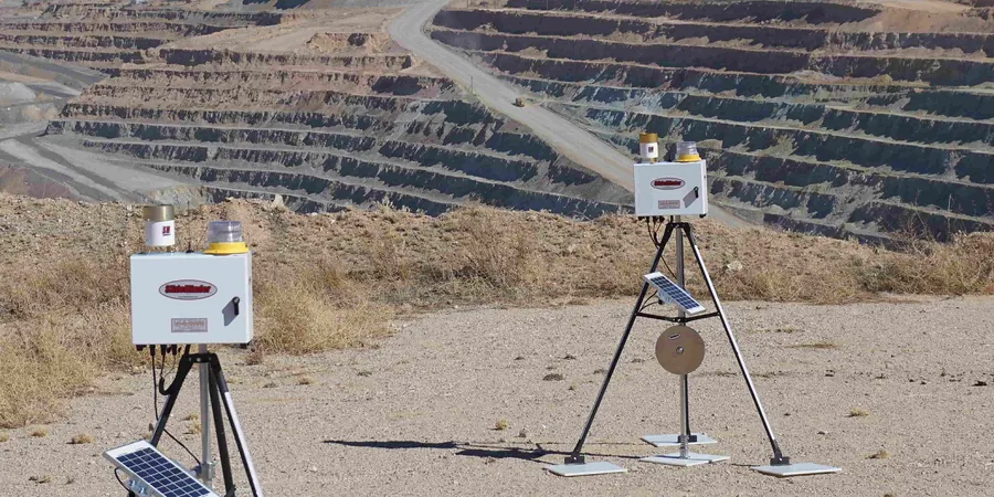
Our services
Our geotechnical excavation monitoring in Gisborne is structured around two core service levels, from weekly manual surveillance to fully automated real-time systems. We tailor the instrumentation array to the site's specific ground model and the council's consent conditions.
Real-Time Automated Monitoring System
A network of in-place inclinometers, vibrating wire piezometers, and automated total stations that stream data to a secure web portal. The system sends SMS and email alerts when pre-set thresholds for lateral movement or pore pressure are exceeded. The 15-minute logging interval captures transient events that weekly manual surveys miss entirely, particularly during rain events or adjacent deep compaction work.
Periodic Manual Surveillance and Reporting
Weekly or bi-weekly visits by a field engineer using manual inclinometer probes and standpipe dip meters. This approach suits smaller residential earthworks or sites with a well-characterised, low-risk soil profile. Each visit concludes with a concise technical memo that compares current readings against baseline, with photographs and annotated cross-sections for the project file.
Frequently asked questions
What triggers a stop-work threshold during excavation monitoring in Gisborne?
Thresholds are set in the construction monitoring plan and are specific to each site, but a common trigger in Gisborne's alluvial soils is a lateral movement exceeding 15 mm over a 24-hour period or a sudden spike in pore pressure exceeding 70% of the estimated passive resistance. We also impose a vibration threshold of 5 mm/s PPV near unreinforced masonry buildings, which are common in the inner city. Any breach generates an immediate alert to the site supervisor and the design engineer, and work in the affected zone pauses until the cause is assessed and mitigated.
How much does a geotechnical excavation monitoring programme cost?
For a typical basement excavation in Gisborne, a monitoring programme generally ranges from NZ$1,570 for a short-term, manual-only setup to around NZ$3,690 for a fully automated system with cloud reporting over a two-month period. The final cost depends on the number of instrumented sections, the depth of the excavation, and the frequency of reporting required by the council consent.
How does the local geology affect the choice of monitoring instruments?
Gisborne's interbedded sands and silts are prone to internal erosion and rapid pore-pressure equalisation. This means vibrating wire piezometers are preferred over pneumatic types because they respond faster to pressure changes. In-place inclinometers with MEMS sensors are chosen for their high resolution in detecting the small, incremental movements typical of creeping slopes in the Wharekopae mudstone, which underlies parts of the city.
Do you provide monitoring data in a format acceptable to Gisborne District Council?
Yes, all our reports are formatted to align with the engineering approval requirements of Gisborne District Council. We present data in tabular and graphical formats with clear exceedance summaries, and we can submit directly to the council's online portal on behalf of the client. Our reports reference the relevant consent conditions and include a signed statement from the monitoring engineer confirming compliance with NZS 3404.